Torrential Rain Situation in Japan

In recent news, you hear about torrential rain disasters caused by typhoons, stagnant fronts, and other factors.

On this page we will focus on Japan and explain!

1.Torrential rains in Japan in recent years

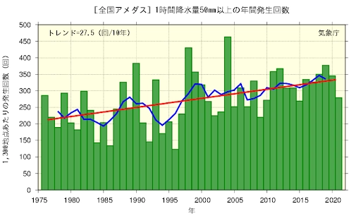
The vertical axis of the right graph shows the occurrences of rain that pours more than 50mm per hour. The horizontal axis shows the number of times heavy rainfall of The rainfall of 50 mm per year will be explained in detail later in the "Experience Report" page, but simply put, it is a disaster-prone, cascading rainfall. The overall trend is that the number of such strong rainfall events is increasing. According to the Japan Meteorological Agency, the average number of occurrences over the last 10 years is 1.4 times higher than the average number of occurrences over the first 10 years, a very serious situation.

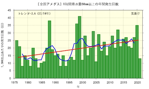
The vertical axis of the right graph shows the occurrences of rain that poursmore than 80mm per hour. The horizontal axis shows the number of times heavy rainfall of 80 mm per year is a level at which disaster is almost certain to occur and is so intense that it is oppressively oppressive that it is difficult to breathe. Although the overall frequency is lower than the 50 mm/h rainfall, there is still an increasing trend. The average number of occurrences over the last 10 years has increased 1.7 times the average number of occurrences over the first 10 years, and the fact that there is an increasing trend over 50 mm/h suggests that the overall rainfall has increased significantly.

2.The countermeasure in place in case of heavy rain in Japan

(Adapted from "Poster and leaflet on new evacuation information" by the Cabinet Office)

In Japan, the Japan Meteorological Agency sometimes issues warnings and special alerts for heavy rain and wind storms when large-scale torrential rains occur. The warnings are communicated to the public through administrative radio broadcasts in the target area and nationwide TV news bulletins. Evacuation orders may also be issued at the discretion of each local government.

In addition to heavy rain and storm warnings, the Japan Meteorological Agency also issues landslide disaster warnings and flooding hazard information. As you can see from the table above, evacuation orders are issued by municipalities when a sediment disaster warning and a heavy rain or storm warning, which correspond to alert level 4, are issued. Also, flooding hazard information is equivalent to Alert Level 5, which requires immediate safety measures. We ourselves need to act early.

Furthermore, the JMA not only issues warnings, but also”Kikikuru” which is a map showing the level of danger in the area divided into five alert levels, is updated every 10 minutes and provided on the Internet.By using this map, you can see at a glance the disaster situation in yourself and your surrounding area. You can also check the disaster situation not only in your area but also that of your family and friends who live far away. It is important for us to use these services provided by the government to protect our own lives.

JMA "Kikikuru" If you are interested in Click here (Ext. Website)