


A pencil, a colored pencil, an eraser, a ball-point
■Radio personal computer smart phone
The radio weather information is broadcast by the program name of a "weather report." What can be heard is the 2nd broadcast of NHK. Those who cannot prepare radio need to use the "raziru★raziru" application which can listen to the radio of NHK with a personal computer or a smart phone.
The time when radio is broadcast is 3 times every day…
Between 09:10 and 09:30 (observations at 6:00)
Between 16:00 and 16:20 (observations at 12:00)
Between 22:00 and 22:20 (observations at 18:00)
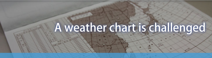
■Weather chart paper
The weather cover is what Japan Weather Association made, and is sold in a network, a bookstore, etc.There are two kinds, No. 1 and No. 2, and both prices are about 500 yen in one-volume entering 50 sheet. In addition, No. 1 is a paper for beginners with the table as which the weather for every place other than a weather chart, etc. are filled in.No. 2 is a type as which there is no table as which the weather for every place, etc. are filled in, and it fills in a weather chart directly. The Japanese writing paper of the feature of the map without a table by which part printing is carried out is large.


If a program starts "it is a weather report at the time of the Meteorological Agency Forecast Department's announcement O moon O day O.It is the weather for every place first... Since it is broadcast as ", time and time are entered in the upper left of a weather chart paper.


It read "In titizima, winds are the wind force 3 and fine, 1018 hPa, and 24 ℃,blowing from southeast." You write it.If it is as an example, a line is first drawn to southeastern one, the feather of 3 wind force is attached, and a fine sign is written in into a circle. And the lower 2 figure of atmospheric pressure is written to the left of a sign, and temperature is written to the right. When it is hard to write, even if atmospheric pressure and temperature are shifted up and down and it draws them, they are OK.


Although it is similarly written as the weather for every place, since marine information changes a measurement position every day, latitude and longitude are read out in front of the weather. A circle is written to the position and the weather is written.

This is read in order of "low pressure" →"front" → "high pressure."


Finally the information on an isobar is read 1 to about two. This explains where latitude longitude passes. It is easy to write that the contour line of a map is imagined and written.